A compilation of article readings about Maps and Islands
Atlantis, No That Would Be Silly
(c) K Wicks

A compilation of article readings about Maps and Islands
Atlantis, No That Would Be Silly
(c) K Wicks
Further to previous articles about maps and islands, An Island, Or Was It? and Atlantis? No That Would Be Silly, I spent some more time looking through maps of the 1500’s. One in particular is currently a favourite which you may be familiar with – Urbano Monte 1587. And an earlier one too, the Mappa Mundi. But in between there are others, showing places that apparently were, but no longer are. Named, routed and landmarks noted. But as far as we are told, they didn’t exist and were just bits of fiction added, or they just ‘got it wrong’, which may well be the case, we know that just because it is drawn or written, doesn’t mean it is real.
I noticed what looked to be an interesting feature on the 1587 map though, a spiral named as Vorago. Naturally I looked up the word, with its meaning being put as – An engulfing chasm : Abyss. And it seemed awfully close to where we have magnetic north showing, a strange feature which looks as though the images aren’t stitched together properly, so it appears fragmented and pixellated, like what happens when you curve something that isn’t supposed to be curved, but what do I know.
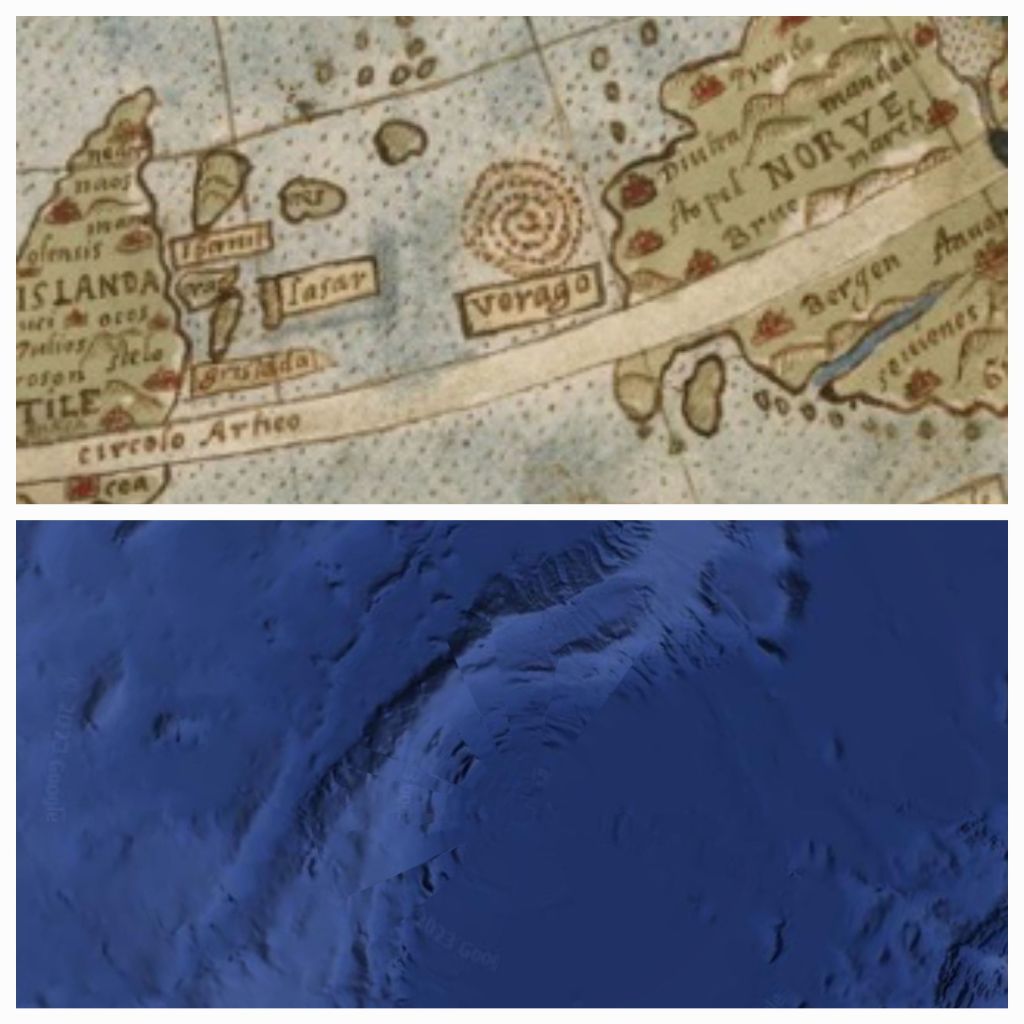
And it can be seen as a diamond formation of dots on earlier maps, this one noted as 1380 in roman numerals, seems very different from the other maps of that time, being that the mappa mundi is apparently from 1300.
And although it is speculated that most of these places noted above, are in fact modern day Iceland, Greenland, Shetlands Islands and The Orkneys – they say the others just simply don’t exist. Although, when you look at google earth today, there are shapes within the area which could have once been islands perhaps. Which leads back to a reoccurring question for me, if the water level has risen and fallen over time, to reveal land once lost, or cover land we once knew, how could that possibly happen? Could the land tilt, rise or drop? Or is it the water levels that have changed, draining every now and then and creating land bridges and bigger continents for a time, only to be covered again by a deluge from above. As the old saying goes, the waters above, and the waters below…
(c) K Wicks

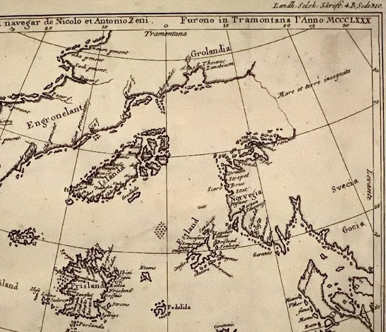
You may or may not be familiar with the so called ‘fictious’ island known as Frisland. I am not one for just going with what ‘they’ say, so like to do a bit of digging to see what it’s all about. And this one I find interesting, because it is purported to be a completely made-up island, as so “Frisland, also called Frischlant, Friesland, Frislanda, Frislandia, or Fixland, is a phantom island that appeared on virtually all of the maps of the North Atlantic from the 1560s through the 1660s”. So, for over 100 years, all sorts of cartographers, from all over the place, just happened to ‘make up’ an island on every map. Sure Jan. Convenient way though to just erase a bit of the past, isn’t it? “Oh, don’t worry about THAT, they just made it up, move along, nothing to see here. But we’re not making it up…” Here is one of the maps of the time to give you an example of what there is to see.
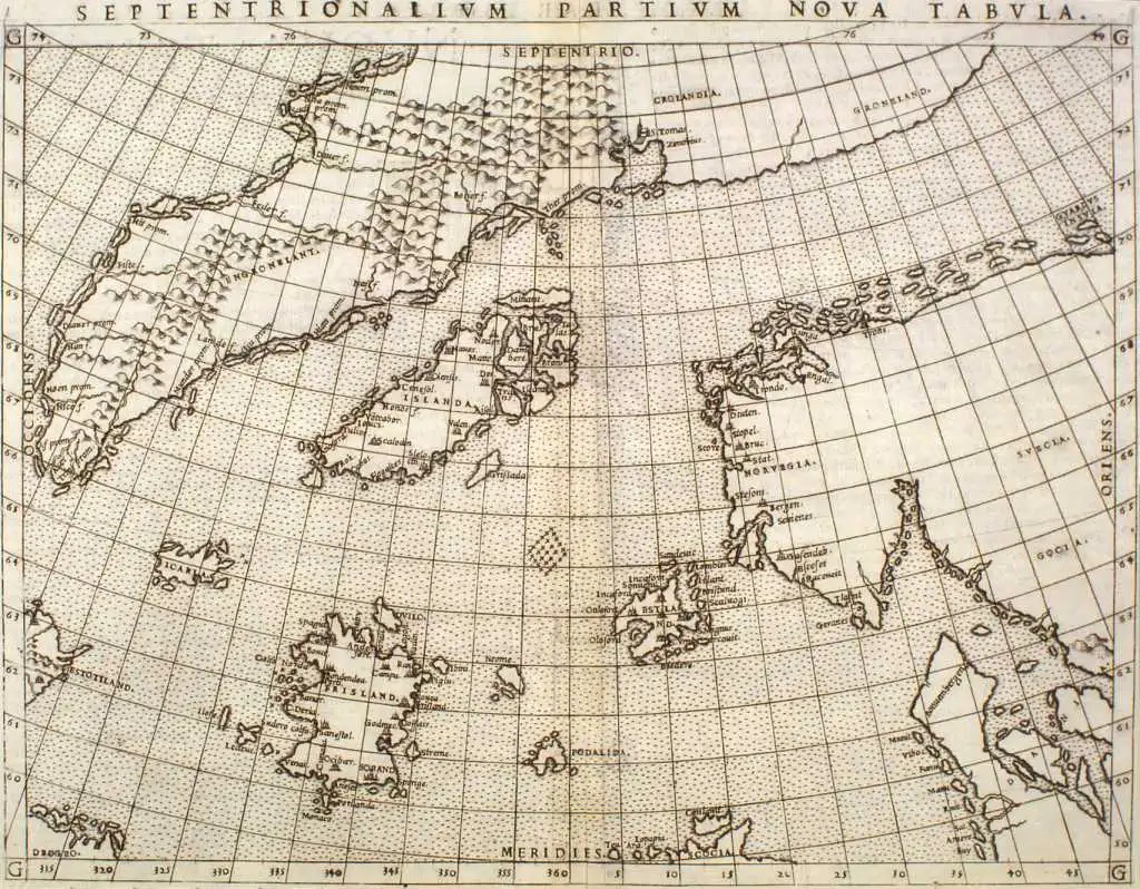
So, we have very clearly all the other places we know exist today, with very detailed coastlines, names of places and mountain ranges etc. But for some unexplained reason, not content with actual coastlines and landmasses to chart and record, no, they just made them up out of the blue. Main question would be, why? And when everything else appears so accurate, even the little island looking bits along Norway’s coast, if you zoom into those edges today, they appear as sandbanks. So why would I think they just made it up! That’s the bit that makes no sense. Unless, you realise there may have been land masses they didn’t want anyone else to know about as time went on, or areas that would reveal too much. And like I said, the ocean may have also changed its route, course and coverage of the land, showing certain areas as perhaps, Pangea or Gondwana to show ‘when the land was attached’, but maybe it’s always been attached, just underwater. With seasonal changes over a long period, what they are now calling climate, could in fact just be cyclical cooling and warming of our dome, which makes the ice melt, causing potential catastrophe but leads to a way out, or it gets cold and freezes meaning more land is revealed and we get to see a piece of what came before. Although, we don’t really, because certain institutions were formed to make sure they are the first ones called to anything of historic significance. They then take as long as they like, often under a veil of secrecy to ‘investigate’, then sometimes years later, we get a public ready piece of information about said discovery. So much more is known than we have been told.
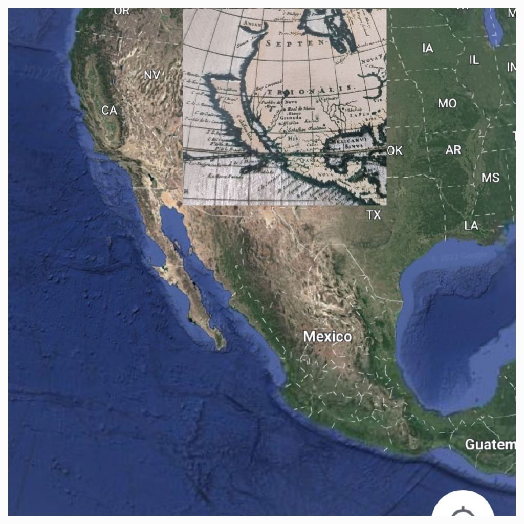
But with the mysterious islands, and various tales of other and different lands, is it so far-fetched to think there is more? And given how many lies have been told about history, to suit the victor, I think it is correct to question that which came before, and that which we apparently see now, because as know, looks can be deceiving and you can achieve an awful lot if people just believe unquestioningly, something to be true. And they are discouraged from questioning, or looking, or wanting to see for themselves. If there is nothing to hide, then surely it makes no difference whatsoever if someone chooses to give it thought. Because sometimes one thought can lead to another, and curiosity, if present, should take it from there and form ideas and further thoughts and questions. I am more than happy to accept that people just got it wrong, repeatedly, all over the world for hundreds of years, but I also equally happy to accept that it has been orchestrated to appear as such, moulding a very small and controllable world by way of maps, programming and repetition. It may well be that California was never an island, and didn’t have a very straight cut off line, which now appears on current maps as the border between California and Oregon, despite first-hand accounts from people having sailed round it. And while doing their straight line, they clearly didn’t notice the rest of the land, instead electing to show it as water. Silly people of the past, can’t even draw maps properly! Or so we are told…
(c) K Wicks
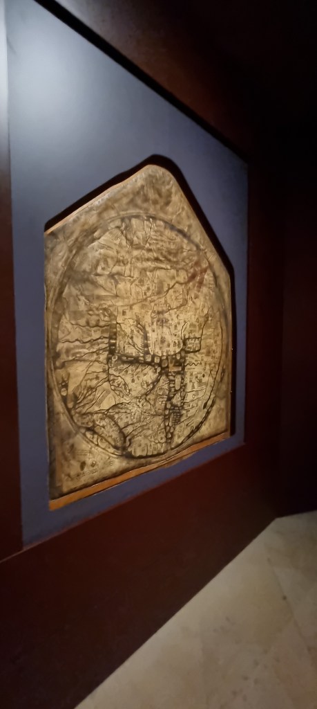
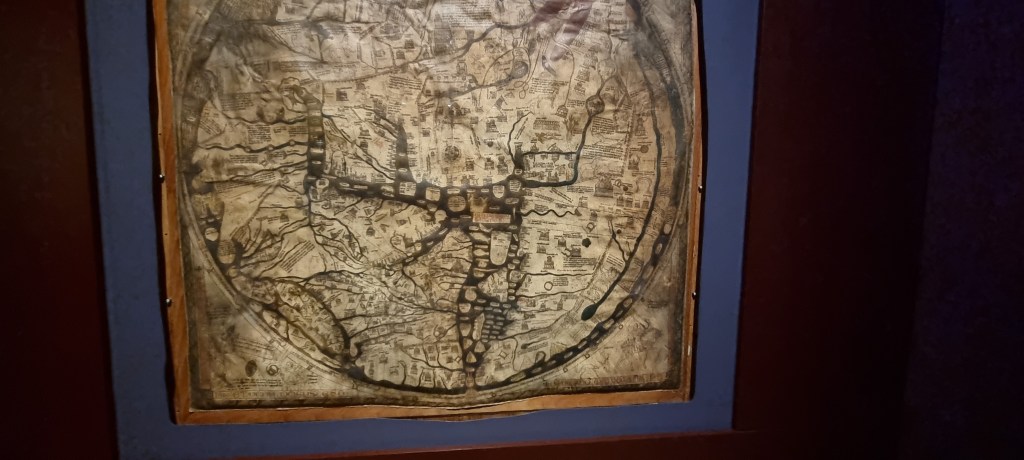
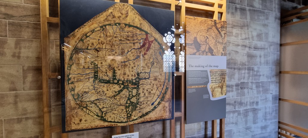
An old medieval map. From the 13th century they say, and is said to be the largest of the old maps. This one resides in Hereford Cathedral. The drawn version is below, so you can see the detail and locations of things. Haven’t things changed a lot since then? They say people just got maps wrong back then, but perhaps things were different, and the land and water distribution was not as we know it today.

(c) K Wicks
